Monthly Archives: January 2014

Predicting the weather

Predicting the weather is not a trivial matter when traversing multiple continents over the course of more than a year. We need to have an idea of what the temperature will be to make sure we have enough warm things. And, almost as importantly, to make sure we’re not carrying around unnecessary clothing (weight savings!).

At many weather sites you can search for a city and then look up the monthly temperature averages, but this is cumbersome. I don’t have a list of cities handy, and my understanding of the geography for the entire trip is limited. I was recently introduced to WeatherSpark.com and now I’m a big fan. It doesn’t just give you weather averages, but makes pretty graphs and has a ton of features. Check out this screenshot.

screenshot from WeatherSpark

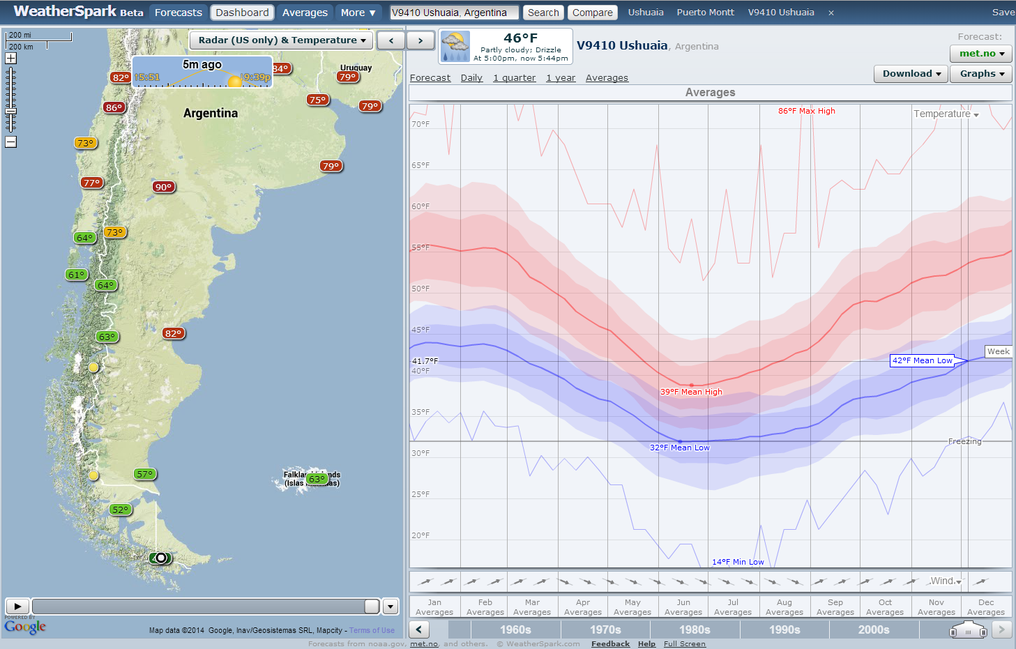
Map of weather stations and temperature averages from WeatherSpark.com. Note the range of highs (reds) and lows (blues). Weather is highly variable!

Recently I planned a rough guess of the countries and the month we might pass through. Then, I powered up WeatherSpark to see which cities there were data for. Not only can I navigate easily between cities (and even know which cities there are data for), I can plot yearly curves of temperature. And they aren’t just average temperatures, but a distribution. This is very important, since temperatures tend to be highly variable! Needless to say, I am impressed.

Soon after I realized you could plot about 15 different weather variables and I got more excited. As a cyclist, the main weather concern is temperature. However, rainfall (or, dare I say it, snow!) and strong headwinds are definitely worth watching out for. When you’re outside almost the entire day, you want to make sure you will be comfortable.

OK. I’m done raving about the website; let’s look at what information I gathered. 

temperature table, Alaska to Nicaragua

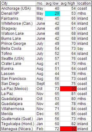
Average temperatures for the first half of the trip.

Our start date is fixed because we already bought airplane tickets. It looks like it will be pretty cold in Denali NP, at 29°F (-2°C) for the average low in May. Brrr. But, we knew that already, and we bought some warm sleeping bags and other gear for the cold weather. We’ll keep our fingers crossed that a cold snap doesn’t hit while we’re there!

The next thing I was curious about was Mexico. We don’t want to get there too soon and be roasted as we travel through the desert down the Baja California peninsula. It looks like it will be a toasty 90°F (32°C) for the average high in October! Honestly, this wasn’t as bad as I was expecting. That is probably because La Paz is on the coast. In any case, it will still encourage us to spend a little more time in the US to wait out the hot summer temperatures.


What I really didn’t know about was what the weather would be like way down south – for the last couple months nearing Ushuaia. The good news is that it should be right on par with the temperatures at the start of our trip, in Alaska and Yukon. Lows near 40°F (4°C) are quite bearable when camping. (Or you can at least agree that we will have tested our gear already to know!)

temperature table, costa rica to chile

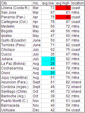
Average temperatures for the second half of the trip.

The big surprise for me was how cold the nights will be in the high elevations in Peru and Boliva. We’re talking about places only about as far south of the equator as the Yucatan peninsula is north of the equator. The average lows are below freezing in places like Juliaca, Peru (12,549’, 3825 m), La Paz, Boliva (11,913’, 3631 m), and Oruro, Bolivia (12,159’, 3709 m). Who knows how cold it will get on other mountain passes — where there wasn’t temperature data for me to look up. Hopefully not much colder, but I guess we’ll find out next year!

What to bring: Sleeping gear for camping

This is the first in a series of posts about specific gear that we plan to bring on our trip.

tent with meditators

A comfortable position for meditation, but a sad looking tent!

We’ll be camping many nights on our upcoming trip. For that reason, it is important to be comfortable while in our tent – whether the conditions are cold or hot, wet or dry. Once you’re on the road long enough, you will hit all conditions, including those most unpleasant. Let’s take a look at the gear we’ll bring.

Tent – Having a good quality tent is a must for comfort. It must have low, waterproof fly for those days when it is pouring rain. The fly can be removed to provide more circulation in hot weather. Also, it is best to have enough space to relax in the tent. When you are caught in a bad rain, it is nice to pass the time playing cards. Finally, we like to have enough space under the fly but outside the tent to store bags and dirty shoes. We got our tent from REI (Quarter Dome T2 Plus).

snow and wet tent

A night where we needed both warmth and waterproofing.

Sleeping bags – We’ll be hitting some cool nights in Alaska – likely down near freezing. Warm sleeping bags are a must for a good night’s sleep! We considered buying silk liners for extra warmth, but decided we wouldn’t need it. We have 20°F (-7°C) bags, and will switch to 40°F (4°C)  when we get to warmer climates. We got our warm bags from GoLite.

Sleeping pads – The big choice here is whether to go with foam or inflatable pads. (We did not consider for a second to not have a pad!) Foam pads are great because they can’t pop/deflate, but inflatable pads are great because they pack up into a smaller space. Both get you off the cold ground which is helpful. We’re planning to use our self-inflating open-cell foam pads (from Therm-a-Rest). We’ll probably pack a patch kit in case we puncture them. I have read about some folks taking both types of pads… maybe that is excessive?

Pillows – Are not necessary for short trips, but they are essential for long-term comfort. After weeks and months of sleeping in your tent, you don’t want to develop a neck or back ache from not having a pillow! I think pillows are are very personal, and a good fit will depend on your preferences. We decided to go with small inflatable ones, which have two different fabrics on the two sides – one better for hot conditions, and one for cold.

sleeping bag and pads

Sleeping bags and pads in their stuff sacks. Kindles, cards, and headlamps are often used in our tent, too!

Stuff sacks – Preferably waterproof, you’ll need bags to store each of these items in. Usually they come with each item you buy. Don’t lose them! Without the bags, your supplies will never pack down into small places. Compression bags are also great for clothing, but we’ll get into that in another post.

And last, but not least…

Bear spray – This isn’t necessary for physical comfort, but in bear-prone areas, think of it as your cuddle buddy for sweet, unworried dreams. This is best used when touring solo!

Training in Spain’s Canary Islands – Part 1: El Hierro


The Canary Islands - part of Spain but much farther south!

The Canary Islands – part of Spain but much farther south!

It’s true, I spent my winter break in the fantastic Canary Islands.  Nearly every winter for the past eleven years I have spent this time with my wonderful host family, who I met when I was an exchange student during my junior year of high school.  They are such marvelous people that I am willing to sacrifice 2 days of travel in each direction for the privilege of seeing them again.  This year was no different, except that I spent even more time than usual riding my bicycle.

For the past three years, I have brought my folding bicycle (a Brompton) along for adventures, exercise, and exploration.

El Hierro - the smallest of the Canary Islands

El Hierro – the smallest of the Canary Islands

The islands we stay on, El Hierro and Tenerife, are known for their biodiversity, volcanic origins, and very steep roads.  El Hierro is approximately one half of a massive volcanic cone.  The other half of it fell off into the ocean millenia ago.  The island, however, is far from volcanically dormant.  For the past two years there have been earthquakes and an underwater eruption off the southern part of the island.  I was there for the biggest earthquake yet – 5.1 on the Richter scale.

My host-father riding on a somewhat flat part of the island.

My host-father riding on a somewhat flat part of the island.

A flowering cactus plant

A flowering cactus plant

My family stays near the center of that crater, and so I took trips on my bicycle up and over the lip of the cone.  This is a climb of nearly 4,000 feet!  Needless to say, the roads are steep and the views breathtaking.  The descents are chilly, but it’s nearly always warm at sea level.  My host father came along on a few adventures.  We always seem to find new unexplored pockets of the island, and new bits of plant life to identify.  Here are a few pictures from around the island.

A road perched on the steep mountainside


Of course, some of the most spectacular vistas are found along the ragged shore where half the island seems to be missing.  The trailing rocks leading from the island into the Atlantic are called the ‘Roques del Salmor’ and are a symbol of the island.

Me and my wonderful host-sister.  Her father was sure to pose us with the Roques growing out of our heads.

Me and my wonderful host-sister. Her father was sure to pose us with the Roques growing out of our heads.

A road perched on the steep mountainside

My host parents, also posed with the Roques.

An example of the off-the-beaten path roads.

An example of the off-the-beaten path roads.


On the high part of the island, it feels like you are on the top of the world, just perched on the edge.  On a clear day, you can see three other islands in the archipelago: La Palma, La Gomera, and Tenerife.

Grazing land on the high part of El Hierro.

I hope to some day return to the Canary Islands with Jason to take a hiking holiday in La Palma or La Gomera.  Both are islands with extensive hiking networks, friendly people, and pleasant year-round weather.  Perhaps after the trip, on my next visit to see my family!

Even after three years pedaling this small island of El Hierro, there are still more roads here I haven’t had the chance to ride.  This years rides provided me with a much-needed dose of vitamin D and a few extra muscle fibers for our upcoming trip!

Some roads were in better shape than others...

Some roads were in better shape than others…


Staying the night: camping, hotels, and other options

Where we’ll be spending our nights will vary by locale and country. We expect to start the trip with a lot of camping, to help keep costs down in the US and Canada. Once we hit Central America we plan to stay in hotels more often. Throughout the trip we also hope to stay with local hosts.

wild camping

Our worst “wild camping” site ever – it got dark and the road went uphill, so we camped in a ditch.

In the US and Canada – Campgrounds are prevalent. The only trick is to try and get a reduced rate since we don’t want to pay $40 for an RV site! In OR and CA, many state parks

tent in the bathtub

After a rainy night of camping and a rainy day of cycling, a hotel room provides some important amenities.

have $5 per person hiker/biker sites. This is great because really all we need is a 8’x8’ area to pitch the tent, not an electric hookup and parking spot. When in remote areas, there is the opportunity to “wild camp” which essentially means making camp off the road out of sight. This is an excellent option because it is free and the location tends to be convenient. — Don’t worry, we won’t pass any fences or “No Trespassing” signs!

Points further south – Once entering Mexico and points further south, hotels/motels/hostels get much less expensive, and I read that campgrounds become less common. In some regions, camping is highly discouraged. In others, it is not as safe as we would like to be. We expect to find accommodation in buildings more often during this part of our trip. Once we get much further south, particularly to Chile and Argentina, we will again be camping a lot.

A third option: local hosts – This is by far the most interesting option, and provides the most benefit, since local folks will give you the scoop on all the local history, attractions, and any safety concerns. That includes advice on upcoming road conditions, which may be necessary once we venture further south!

We plan to visit with various friends and family along our route in the US, but in other locales, there are a variety of ways to meet local hosts. The main way is to use warmshowers.org, a website set up to help connect touring cyclists with potential hosts. Another service is couchsurfing.org, which is a site for general travelers. You may be more familiar with this site if you are not a cyclist. Daisy has a profile on Warmshowers and I have one on Couchsurfing so we are ready to go on this front!

Typically, the local hosts will offer accommodation (a bed, futon, or camping spot), and also possibly dinner and some form of entertainment. The only downside, though, is that after a long day of cycling you have to have enough energy saved up to make good conversation! ;) But we’ve noted through past visits and hosting that the cultural exchange is well worth the effort.

a large dinner

Eating a feast at Safeway, right before being offered a place to stay.

More often than you may imagine, random folks will approach and offer a place to stay. An example of when this might happen is when you’re sitting outside the grocery store eating a bag of chips AND a box of cookies, looking a bit dirty, but definitely happy and friendly. It is even better when the person offering to host tells you the story of how their child is on a long-distance cycle tour, and so they try to return the favor of hosting to balance some of the good fortune their child has received.