Category Archives: route (ideas)

Posts about route ideas and the path we have cycled.

Predicting the weather

Predicting the weather is not a trivial matter when traversing multiple continents over the course of more than a year. We need to have an idea of what the temperature will be to make sure we have enough warm things. And, almost as importantly, to make sure we’re not carrying around unnecessary clothing (weight savings!).

At many weather sites you can search for a city and then look up the monthly temperature averages, but this is cumbersome. I don’t have a list of cities handy, and my understanding of the geography for the entire trip is limited. I was recently introduced to WeatherSpark.com and now I’m a big fan. It doesn’t just give you weather averages, but makes pretty graphs and has a ton of features. Check out this screenshot.
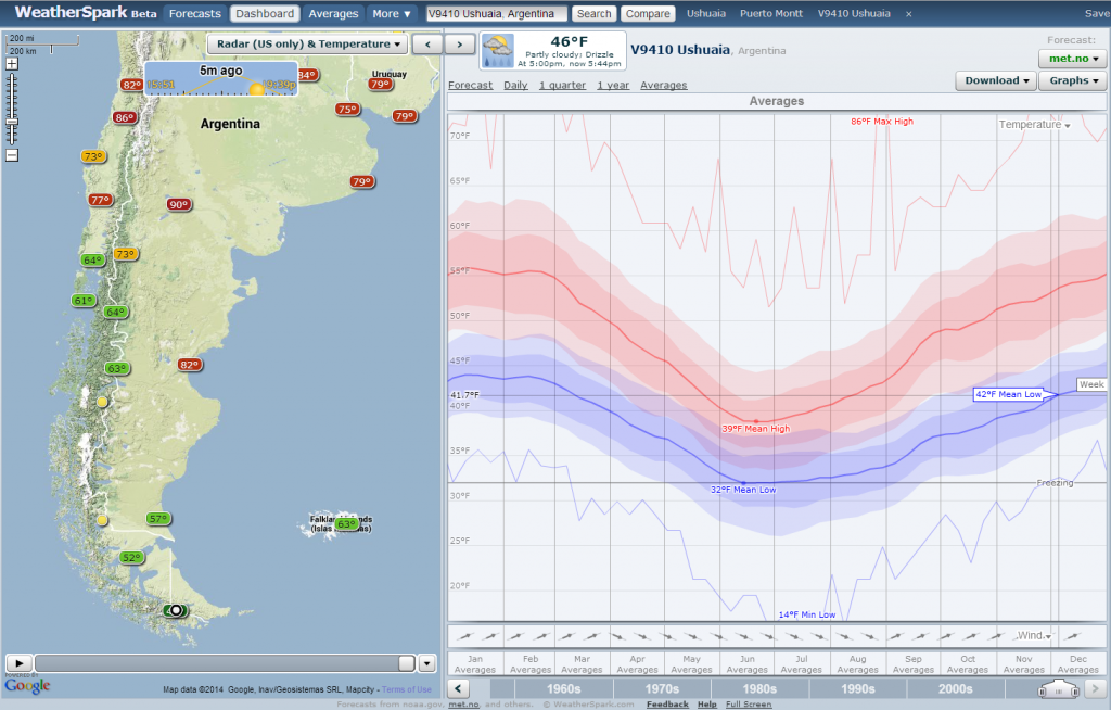
screenshot from WeatherSpark

Map of weather stations and temperature averages from WeatherSpark.com. Note the range of highs (reds) and lows (blues). Weather is highly variable!

Recently I planned a rough guess of the countries and the month we might pass through. Then, I powered up WeatherSpark to see which cities there were data for. Not only can I navigate easily between cities (and even know which cities there are data for), I can plot yearly curves of temperature. And they aren’t just average temperatures, but a distribution. This is very important, since temperatures tend to be highly variable! Needless to say, I am impressed.

Soon after I realized you could plot about 15 different weather variables and I got more excited. As a cyclist, the main weather concern is temperature. However, rainfall (or, dare I say it, snow!) and strong headwinds are definitely worth watching out for. When you’re outside almost the entire day, you want to make sure you will be comfortable.

OK. I’m done raving about the website; let’s look at what information I gathered. 

temperature table, Alaska to Nicaragua

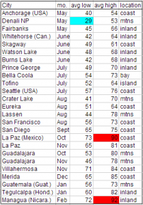
Average temperatures for the first half of the trip.

Our start date is fixed because we already bought airplane tickets. It looks like it will be pretty cold in Denali NP, at 29°F (-2°C) for the average low in May. Brrr. But, we knew that already, and we bought some warm sleeping bags and other gear for the cold weather. We’ll keep our fingers crossed that a cold snap doesn’t hit while we’re there!

The next thing I was curious about was Mexico. We don’t want to get there too soon and be roasted as we travel through the desert down the Baja California peninsula. It looks like it will be a toasty 90°F (32°C) for the average high in October! Honestly, this wasn’t as bad as I was expecting. That is probably because La Paz is on the coast. In any case, it will still encourage us to spend a little more time in the US to wait out the hot summer temperatures.


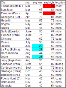
What I really didn’t know about was what the weather would be like way down south – for the last couple months nearing Ushuaia. The good news is that it should be right on par with the temperatures at the start of our trip, in Alaska and Yukon. Lows near 40°F (4°C) are quite bearable when camping. (Or you can at least agree that we will have tested our gear already to know!)

temperature table, costa rica to chile

Average temperatures for the second half of the trip.

The big surprise for me was how cold the nights will be in the high elevations in Peru and Boliva. We’re talking about places only about as far south of the equator as the Yucatan peninsula is north of the equator. The average lows are below freezing in places like Juliaca, Peru (12,549’, 3825 m), La Paz, Boliva (11,913’, 3631 m), and Oruro, Bolivia (12,159’, 3709 m). Who knows how cold it will get on other mountain passes — where there wasn’t temperature data for me to look up. Hopefully not much colder, but I guess we’ll find out next year!
Alaska (Attractions #1)

This is the first in a series of posts about locations and attractions along our route that we plan to visit.

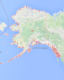
alaska map

Alaska – The Last Frontier

Alaska is the US state with the most wilderness. And, it doesn’t take long to feel the effect once you are there. Simply travel 1/2 hour out of any town and you will be left in the middle of a great expanse of land, with few signs to show man’s marks.

To help us plan the trip, we have been using “The Milepost” guidebook. It claims to be “the bible of North Country travel” and they are right if by that they mean it is a comprehensive and indispensable book! It gives mileage, attractions, and most importantly for cyclists, whether each town has a grocery store. : )

Around 10 years ago I traveled to and through Alaska via motorhome with my grandfather, father, and sister. Traveling by bicycle will be an entirely different experience. Here are a few highlights I’m particularly looking forward to…

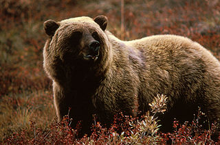
grizzly bear

I fully expect to see one of these bears – but hopefully from a safe distance! (Image: Wikimedia Commons)

Denali National Park – This is the third largest national park in the US. The park road meanders 92 miles into this massive preserve. Daisy and I are planning to spend 4 days in the park — two days riding in towards Wonder Lake and two days back out. There are a few nice hills to ride. Of interest is that the road turns to gravel past mile 13, and is open to buses only. However, since the buses don’t start running until May 20, any cyclists (that’s us!) will have the road to themselves — well, except for the bears, wolves, sheep, moose, and other wildlife! I expect we are guaranteed to see the wildlife, and at times up very close and personal. But don’t worry, we’ll have bear spray!

Fairbanks – This town marks the furthest point north we plan to travel on our trip. At almost 65°N, it is pretty far up there. We will arrive in late May, so will experience almost continuous daylight (plus a little twilight – no, not Twilight). We don’t plan to trek up to the arctic circle, as some cyclists do. Fairbanks is one of the few major towns in Alaska, and it will be a good place to stock up on supplies. Who knows, we may even stop by the university so Daisy can give a statistics talk!

top of the world highway

View on the Top of the World Highway from Google Street View

Top of the World Highway – This is the name given to the road that extends east from Chicken, Alaska to Dawson City, Yukon. The road is almost entirely unpaved and contains few, if any, amenities. In essence, this indicates it will cut through the wilderness. Although we will spend some time on the Alaska Highway, this less-traveled route will provide a different experience.

Haines and Skagway – These two towns are in the small part of Alaska that is squished between the Pacific Ocean and British Columbia. Connected by ferry, they allow us to travel to the coast and back inland without retracing our path. But more importantly, traveling to/from the area will allow us breathtaking views as we pass through the coastal range mountains. While we are in Haines, we will take a rest day without biking. We hope to take a fast boat to Juneau and hike to a glacier.

Honeymoon Recap (Outer Banks Tour)

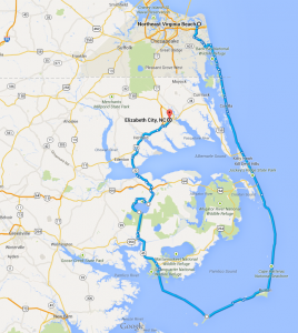
Loop through the Outer Banks of NC; 6 days of riding; 285 mi (460 km)

6-day Bicycle route through the Outer Banks of NC

Bicycle route through the Outer Banks of NC

The trip was a resounding success! We had a great time, our bikes worked well, and we had enough warm gear to keep us going. We saw some awesome sights, including lighthouses and the Wright Brothers National Memorial. And we had quite a few adventures, like getting picked up by the Currituck Sheriff on the beach highway, the Sisyphean sand plows, and the (almost) never-ending muddy wildlife refuge road.

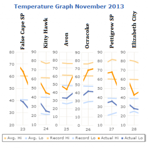
We knew we needed to head south from PA if we were going to have a pleasant bicycle tour in late November, but we were a little surprised by how cold the weather actually was in the outer banks!


Daily temperatures on our trip - colder than average!

Daily temperatures on our trip – colder than average!

On half of the days, the daily high was actually close to or below the average low. Brrr. But this ended up being useful, in the fact that we could test our cold-weather gear. We wanted to do this anyway, since we are planning to start in Alaska in May, and depending on the year it is chilly. We learned that we have enough warm things for our cores, but could definitely use a few items…


#1: Thin wool gloves – Our hands were warm inside the bar mitts, but wool gloves would have been better for wet conditions

#2: Neoprene booties – Our rain covers for our shoes did not hold up, and once our socks got wet our feet got cold. Good booties could remedy this problem by keeping out the cold and wind.

#3: Warm waterproof hiking boots – Our SPD-style riding shoes are actually summer shoes with a lot of mesh for breatheability and contain vents in the bottoms. These vents were great at letting in water! So, for those days that are both quite cold and really wet having some hiking boots would be great to keep our feet both dry and warm. Also, it would give us an extra pair of shoes when one is wet, and for hiking in general.

#4: Flat pedal attachments – We’ll need some pedal attachments to allow use of “normal” shoes if we wear our hiking boots when riding.

In other lessons learned… we definitely will be more careful with our use of Google Maps! There are a lot of roads on map services (and in GPSs) that are not very driveable – or rideable). This makes more of a difference when the road turns muddy, and the winter days are short. Speaking of which, this was our first winter-season tour, and we were caught off guard by how early it got dark! If we weren’t set up to camp by 4:30 or so we were in for a cold dinner — at around 5 PM it got dark.

The final lesson was that we need to get used to our new bicycles and the riding postures. I (Jason) started having knee pain part way through the trip, and it got so bad I couldn’t finish the ride back to Virginia Beach on the last day. We think it was brought on by a change in riding posture – our new bikes are set up to focus on the hamstring muscle group and pulling, as opposed to the quads and pushing – in combination with a lot of hard mashing into the wind. My knee is doing much better now, though, and this is good, since I commute via bicycle to work every day.

Drying the tent and rain fly.

Drying the tent and rain fly after returning home.

Previous trips and other blogs

Darling, this ain’t our first rodeo.

Daisy has logged 10,000+ mi (15,000 km) cycle touring, and has brought Jason along for 3,500 of those miles. Needless to say, we have a good idea of the gear we need, what to expect, how and where we like to camp, what we like to eat, how we like to handle the mountain passes, etc.

If you want to read about some of our previous tours, check out dandjadventures. On that blog we wrote about our trip from Mexico to Canada in May/June of 2012, and about a short Spring Break trip in March of 2013 to Harrison Hot Springs, BC, Canada. Those posts will give you a taste of what we’ll write about as we’re on the road, keep you a little busy while we are still prepping for our Pan-American trip, and hopefully get you a lot more excited about the trip we’ll start in May 2014!

Bicycle touring is gaining in popularity, and I believe since the internet allows cyclists to easily share stories and route ideas, more and more folks keep getting on their bikes. They do this in a variety of ways – from fully loaded touring in remote areas with a tent and food for 4 days at a time, to a light bag packed with lunch and a credit card for motels.

You’d be surprised who is out there doing it, too. Some of our favorite blogs to read are about families. Here are a few blogs that we have followed: The Pedal Powered Family, The Family Verhage, and The Vogel Family.

It is pretty easy to get ideas about where to bike through on our upcoming trip, since there are a bunch of folks blogging about their recent trips! Here are a few we’ve been checking out: Going South, Life is Like a Box of Chocolates, and HOPE.

You can find more by web-searching Cycling the Pan-American Highway or perusing crazyguyonabike.com.

Now that you have plenty of reading material, I can leave you be for now. … Oh, did you think you would get work done today? Have fun!