Trough Creek State Park – we made it!

Wonderful, wonderful, camp chairs.

Daisy + Rainbow Falls + dude photobombing us so he can pick up a Sprite can from the stream and drink it.
The ride south to Trough Creek State park was gentle and pleasant. It was sunny! This meant we realized our third important forgotten item: Sunscreen. Yikes! By the time we rolled into camp at the State park it was only about 3 o’clock, but we were tired and a little red. The ranger gave us site 15, but when we arrived we saw a giant black truck in the spot and a host of little kids jumping around in the tent pad. No thank you! We chose a ‘walk in’ site a little bit away and set up camp. It was great to sit in our camp chairs and drink gatorade in the shade. What a relief!
Energized, we decided to go for a hike. Jason realized yet another forgotten item: non-bike pants. Luckily, Daisy’s shorts fit him (!), and she could go in just her Ruu-Muu. We hiked to Balanced Rock, one of the attractions of the park. It was a very large boulder perched precariously on the side of a cliff. We were underwhelmed by the rock, but took great amusement (and horror) from observing a young family with some crazy 9-year-old boys climbing all over the rock and the trees overhanging the cliff. The parents were oblivious, focusing only on each other. Jason and I skedaddled before being witness to a tragedy.

The “Ice Mine” + Jason sporting Daisy’s shorts
We hiked a bit more to see the ice mine, the parks other main attraction. In truth, the hike was more lovely than the mine, but the mine was neat too. It was essentially a very cold spot in the ground with icicles even in the 70 degree heat.

Daisy cooking dinner at our campsite in TCSP.
The next day we got a slow start… not leaving camp until around 10am! We would come to regret this as the day heated up and the sun got stronger. We started the day with a pleasant climb on gravel roads, and a descent into the neighboring valley. A tailwind pushed us for the next some miles until the next climb over another ridge, following by a roaring descent to the Juniata river.

The first descent of the day!
We stopped for lunch along the banks of a small stream. Jason commented as we set up ‘I bet there aren’t any trout in this little thing!’ Then we proceeded to see three huge trout swim past! They were each about 10 inches long. Wow!

Can you find the trout?
The rest of the day was a bit of a struggle-fest. We had a large amount of very very steep climbing to do in the hot sun. It was over 80 degrees! We despaired more than once, eventually trading quiet hilly country roads for a busier and more flat alternative. No matter, we were hyper visible and the cars were all quite respectful. We limped to our last stop before the final climb. Ice cream! Pulled pork sandwich! What lifesavers. It is so fantastic on bike tour to find these little restaurants (even in our own backyard, a mere 12 miles from our house!) that we have never tried before.

View of PA hills, from the top of one very steep hill!
We had to stop every half mile or so on the way over that final steep ridge, but make it we did. It was a great relief to coast down the other side and pedal lazily back in to town. Back at our apartment, we immediately laid flat on our backs on the living room floor, unable to do anything but drink some more water. Eventually, of course, we showered off the dirt and grime of an adventurous weekend. Now, we just need to keep lotioning the sunburn. We will hopefully never forget any of those essential items again!

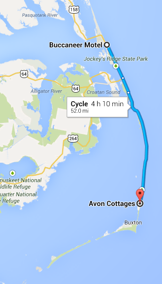
Route back home to State College (day 3). It was full of climbing!

Day 3 elevation profile